
Geoscience or earth science is not only about boring theories. There are many practical implementations of the knowledge of geoscience in real life. And, there are some computer programs which will help you to simulate the ideas of this important field of science. Normally, students and academicians of geoscience use these tools. For this reason, common people don’t know much about these geosciences software. But if you are an avid learner of geoscience and a Linux user at the same time, you might want some best geoscience software for your Linux system.
Earth Science or Geoscience Software for Linux
Many people have a misconception that these specialized tools are not available for Linux distros. It’s true that there is not a huge number of geoscience software for Linux, but the number is not negligible either. So, it’s very difficult for you to choose the best piece of software for your practical study or research. Don’t worry, here we are going to introduce you to the 15 best geoscience software for Linux.
1. GRASS
Geographic Resources Analysis Support System or GRASS is an open source software used in geoscience. It is a GIS or Geographic Information System. That means it will help you with the analysis, image processing and visualization of geographic data. It was originally developed by the US Army and then gradually enhanced by the open-source community. GRASS is regarded as the most advanced GIS software and hence it is used by different government and private officials all over the world.
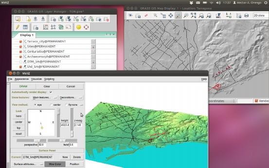
Key Features of GRASS
- Easy to use wxPython graphical user-interface included with Layer Manager, Map Display Window and Module Dialogue.
- It has around 400 built-in modules for data analysis and image processing.
- It has a large community-driven library of free downloadable add-in modules.
- GRASS has an integrated 2D/3D vector processing engine with support for SQL based database management system.
- The Python interface to the C library helps you creating powerful modules of your own.
- This program can be used as the backend of other GIS software.
Get GRASS
2. Quantum GIS
Quantum GIS is yet another GIS software for Linux. This Linux geoscience software is mostly known as QGIS. The main aspect of this tool is its user-friendliness. The initial goal of this tool was to provide a GIS data viewer. But over the time it has become a complete package for GIS functionalities. It will help you to create, analyze, query and view geospatial data.
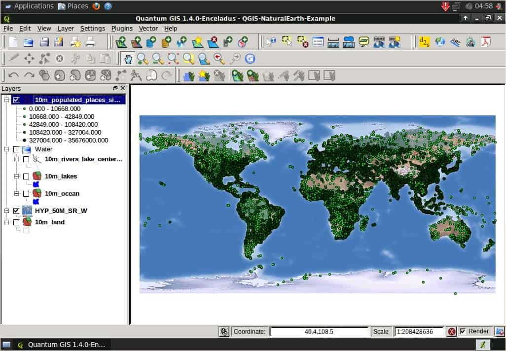
Key Features of Quantum GIS
- It has support for a wide range of formats for viewing raster and vector data. Another interesting this is that it doesn’t need to convert data to a common format for doing so.
- QGIS supports all the formats from two very popular libraries, such as the OGR library and the GDAL library.
- Quantum GIS has a very user-friendly graphical UI with some important built-in, including a map composer, spatial bookmarking, feature labeling, overview panel, etc.
- Users can perform spatial analysis using integrated GRASS tools, including map algebra, terrain analysis, hydraulic modeling, network analysis, and many others.
- It has got a plethora of plugins for installing and add extra functionalities like decorations, georeferencer, GPS tools, GRASS, Python console, etc.
3. Survex
The tool Survex is an open-source software package for analyzing and viewing cave-survey data. Surveying a cave is not an easy task but this tool makes it easier to analyze the survey data. The real-time cave viewer integrated with it helps you to the panning, rotating and zooming inside the cave using your standard input device like mouse and keyboard. Many important governments and non-government survey projects rely on this software.
Key Features of Survex
- Integrated lag-free and super smooth cave viewer with redraw and bank-switching techniques,
- Inbuilt instrument simulators have an optional scale and zero correction.
- Users can specify magnetic deviations separately where needed.
- Survex has support for almost all the common input units like meters, feet, degrees, mils, grads, minutes, etc.
- This tool supports a wide range of languages including French, Spanish, Portuguese and Slovak.
- This tool has integrated printer drivers for almost all the common models including Epson, Canon, HP, etc.
4. SAGA – System for Automated Geoscientific Analyses
It is free and open-source geoscience software for Linux. All the functionalities of this program can be easily accessible by using the GUI or by writing command lines. You can also program it by using C++ API. This API system allows you to write new algorithms for analyzing geographical data. It features an exchangeable modules library for geoscientific methods.
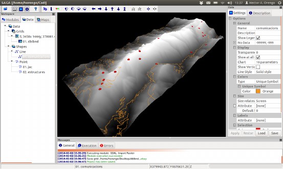
Key Features of SAGA – System for Automated Geoscientific Analyses
- SAGA supports various formats for inputting data like grids, tables, vectors, images, etc.
- This tool supports interpolation for various vector data using triangulation, nearest neighbor and inverse distance.
- Users can use various geostatistics methods like residual analysis, ordinary and universal kriging, single and multiple regression analysis, variance analysis, etc.
- It features some intelligent functions like box classification, maximum likelihood, and pattern recognition.
- Users can simulate various dynamic processes with this tool.
- The advanced terrain analysis feature of this tool helps you to analyze slope, curvature, flow path, solar radiation, etc.
5. uDig
The name of this tool is derived from the catchphrase “User-friendly Desktop Internet GIS”. Just like its name this tool is very userfriendly. It is an open-source geospatial data viewer. Though it is a stand-alone desktop program for Linux, it has many online GIS services built-in. This software is written in Java and developed with Eclipse Rich Client (RCP) technology.
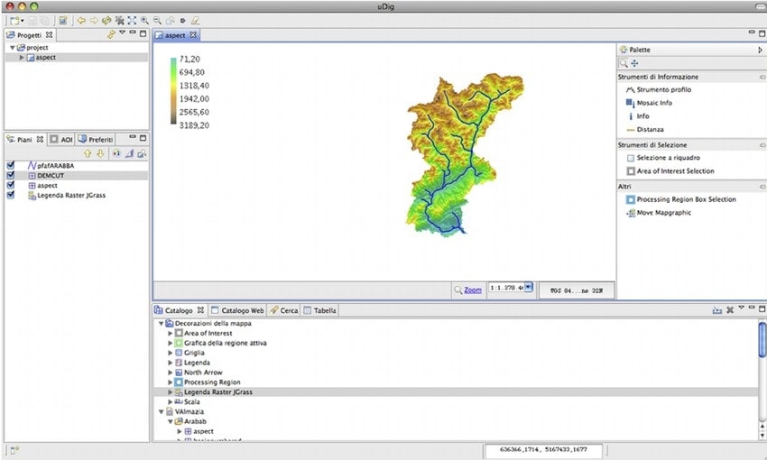
Key Features of uDig
- The Eclipse Rich Client or RCP technology helps to add and develop new functionality for this program.
- It has a feature-rich Java toolkit that can be used by the developers to develop this open-source tool.
- GRASS is used for vector operations in this program that helps the users already familiar with GRASS.
- The desktop client supports drag and drops feature to interact with file explorer and web browser.
- It supports GeoServer, MapServer and other kinds of web map servers.
- Users will get a fast user experience while working with maps and links because of its embedded web browser.
6. Therion
Therion is an advanced cave surveying tool. It is a command-line based application. It takes input in text files but the output can be retrieved as a 3D map and visualization. But other than that the uses of this application are pretty simple. It is fully compatible with Survex and the data can be stored either in the form of a Survex file or a Therion file.
Key Features of Therion
- The map drawing is fully independent of the survey data. So you can draw partial maps if you want to.
- It completes maps with all the details. No additional ink stroke is needed for this.
- The dynamic map drawing system refreshes the output map automatically with the change in scale or value.
- The 3D model of the cave can be split into layers and can be displayed as individual items separately.
- The 2D map input generates a 3D map as output.
- Therion supports a lot of commonly used file formats for exporting data or visualization.
- It has built-in translation support for many languages.
7. GrADS – Grid Analysis and Display System
GrADS is a very advanced tool for access, manipulation, and visualization of geographical data. This tool uses four-dimensional datasets for analyzing earth science data. It has also an optional 5th dimension for grids that are generally implemented but designed to be used for ensembles. It has a rich set of built-in functions for different operations. Besides users and developers can add extra functions by using any programming language.
Key Features of GrADS
- This program displays data in different types of graphical forms. Lines, Bars, Scatter Plots, Smoothed Contours, etc are some of them.
- GrADS can read different types of datasets including GRIB, gridded binary, BUFR, GrADS station data, NetCDF, HDF4-SDS, HDF5, and OPeNDAP.
- It has a programmable scripting interface for displaying complex operations.
- Its advanced scripting language enables users to map buttons using scripts and take actions based on clicks.
- It has a data server named GDS which uses OPeNDAP protocol to analysis service across the internet.
8. GPlates
GPlates is a very useful geoscience software for Linux. The desktop client gives users an interactive visualization of plate-tectonics. This tool is written in the C++ programming language. GPlates uses the OpenGL framework for displaying 3D map output. The graphical user interface of this program uses Qt as its framework.

Key Features of GPlates
- GPlates supports the loading and saving of different geographic and tectonic data in different formats including GPML, Plates4 line-format, ESRI Shapefile, etc.
- It records and restores the previous session of the user. This is a very convenient feature of this tool.
- The tool supports the loading of raster images in different formats like JPEG and NetCDF.
- The visualizer tool supports different types of map projections including 3D Orthographic Globe, Rectangular, Mercator, Mollweide, etc.
- Users can control the perspective camera by dragging the mouse or by using the keyboard arrow keys.
- You can choose different coloring schemes for vector features and NetCDF grids data.
9. Generic Mapping Tools
GMT is a collection of over 80 tools for creating and manipulating geographical data. All the tools are open-source. The tools are mainly command-line based. But there are some graphical user interfaces available from third-party developers such as iGMT, Mirone, SEATREE, etc. This tool comes integrated with a free comprehensive collection of free GIS data, such as coastlines, rivers, political borders, etc.
Key Features of Generic Mapping Tools
- The tools can manipulate cartesian and geographic data sets including filtering, trend fitting, gridding, projecting, etc.
- It can produce PostScript illustrations ranging from simple x–y plots via contour maps to artificially illuminated surfaces and 3D perspective views.
- The package contains 40 more tools for specialized discipline-specific works.
- The tools have native support for more than thirty mapping projections.
- Linear, log10, and power scaling features are also supported by the tools.
10. OpenJUMP
This is an open-source Geographical Information System or GIS. It is written in the Java programming language. It is considered as a unified mapping platform. Maybe some of you are familiar with the software named “Java Unified Mapping Platform.” That was developed by VividSolutions and was released in 2003. OpenJUMP is the open-source fork of that software.
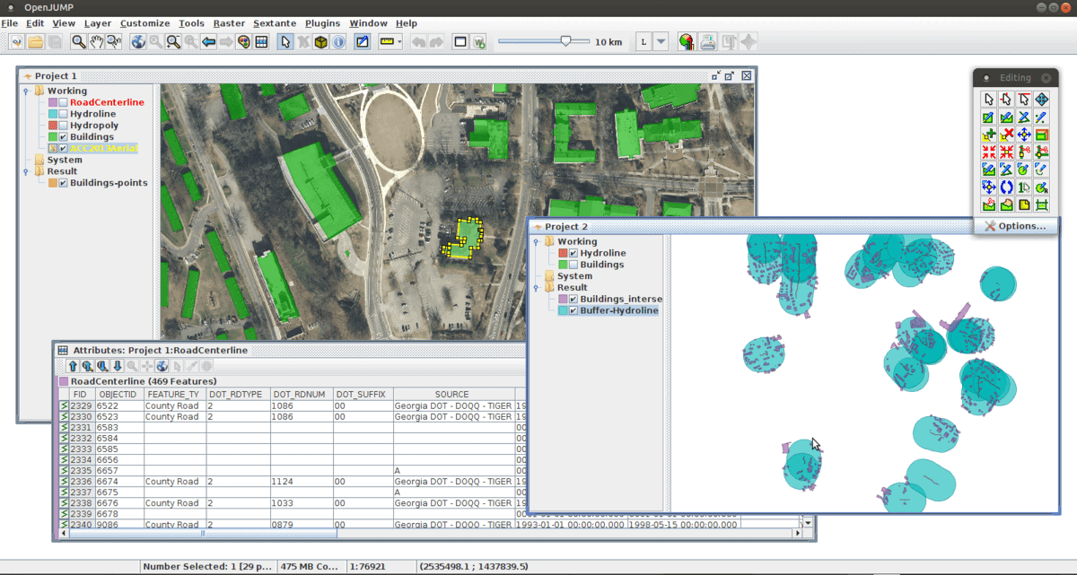
Key Features of OpenJUMP
- It has integrated vector GIS support which can also read raster files.
- This tool provides open API and plugin system which can be scripted by using BeanShell and Java Python.
- It has support for plenty of vector and raster file formats.
- OpenJUMP has some built-in topology tools like line noder, polygonizer, planar graph, etc.
- The advanced measurement tool can calculate length, area, centroid, buffer, convex hull, etc pretty well.
- The advanced printing system makes it easier to print out sophisticated maps.
11. gvSIG Desktop
gvSIG Desktop offers numerous tools for analyzing geospatial data. gvSIG supports a wide range of vector and raster files, as well as databases and remote services. This geoscience software has some bonus tools integrated with it including Coordinates Reference Systems manager, import from/export to WMC, scripting and translations manager.
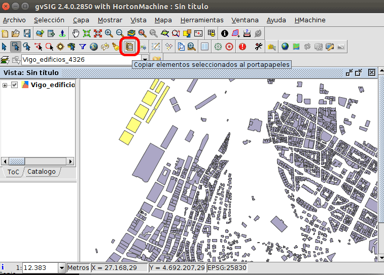
Key Features of gvSIG Desktop
- It gives users access to remote services like OGC, ArclMS, Ecwp, etc.
- It has different types of graphical editing options like adding event layers, snapping, grid, flatness, command stack, undo/redo, copy, move, symmetry, rotate, scale, edit vertex, etc.
- The advanced vector representation system can display different unique symbols, categories, legends, etc.
- It has a printing system integrated that can export files as PDF or as image files and print them instantly.
- gvSIG Desktop can be seamlessly integrated with online map servers to publish maps online.
- The 3D viewing tool built-in with it can display from different perspectives and can make animations automatically.
12. Seismic Toolkit
The Seismic Toolkit is an open-source seismic data analyzer. This tool can perform filtering, spectral analysis, polarization analysis, time-frequency representation, Hilbert transform, and singular value decomposition. Thus it has become a go-to tool for the experts in the field of studying earthquakes. Apart from different seismological analysis, this tool can plot graphs according to the provided data.
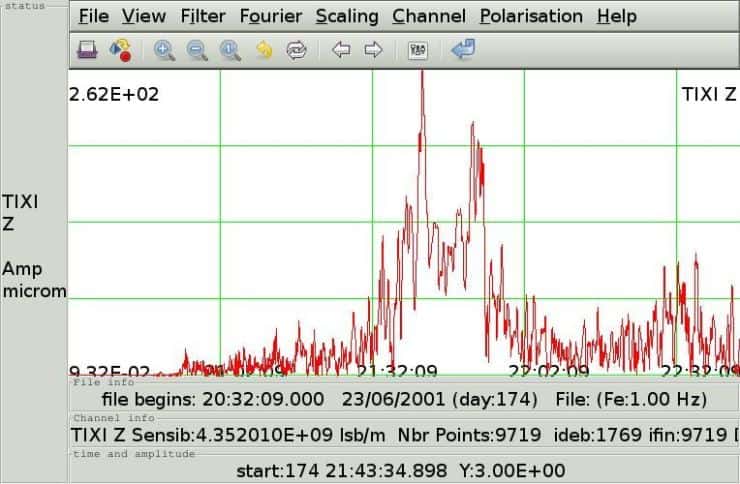
Key Features of Seismic Toolkit
- The powerful raster engine integrated with it supports different display properties including wiggle, variable area, variable density, color-filled modes, etc.
- This tool supports over 200 datum and seven different projection modes.
- Users can overlay any number of seismic datasets and display interpretation or annotate data.
- Seismic Toolkit offers granular control over trace highlight, polarity, visibility, color, etc.
- Image pre-rasterizing system helps bufferless zooming and scrolling over maps.
- The toolkit supports the Qt framework for extended functionality.
Get Seismic Toolkit
13. PostGIS
PostGIS is a spatial database extender for the PostgreSQL object-relational database. It allows running geographic location queries in SQL. It also adds functions, operators and index enhancements into the geospatial datasets. All these functionalities rather make it a database management tool than an analysis software. PostGIS also includes additional toolkits to process and analysis of Geographic Information System Data.
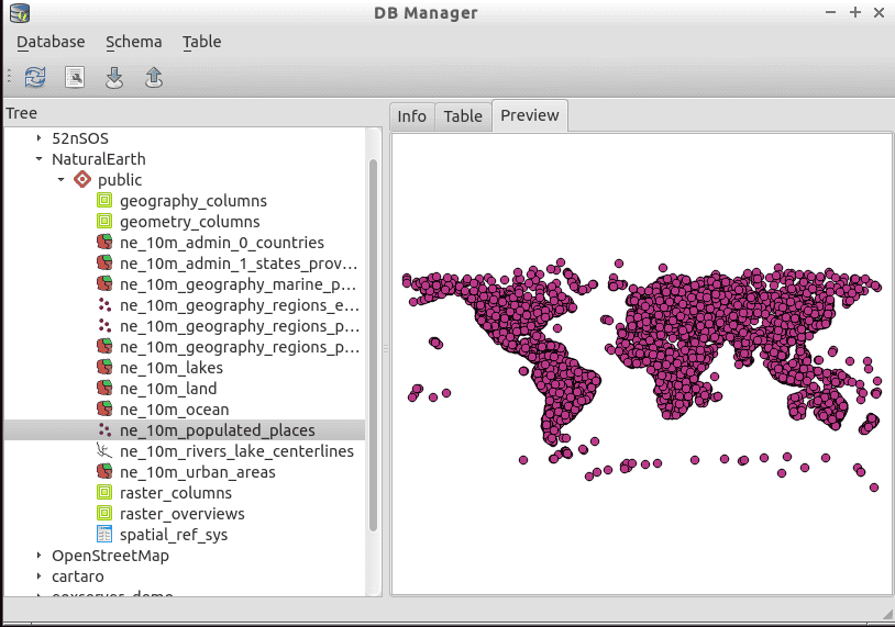
Key Features of PostGIS
- PostGIS splices, dices, morphs and reclassifies both vector and raster data with the power of Structured Query Language or SQL.
- It uses a raster map algebra algorithm for faster and detailed raster image processing.
- It supports importing and exporting ESRI shapefiles for vector analysis via command line or graphical user interface.
- The support for file formats can be extended via using different third party open-source tools.
- It has native support for 3D objects, functions and spacial index.
14. ncview
This is a simple NetCDF file viewer system. ncview is free and open-source. All the features of a geospatial data viewer are integrated with this system. NetCDF version 4 with full HDF5 support is needed for running this tool properly.
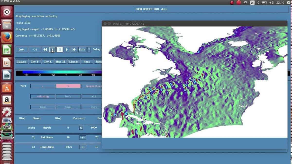
Key Features of ncview
- It can display a 2-dimensional, color representation of data in a netCDF file.
- ncview can automatically animate the data in time to create movie loops.
- The basic properties like flipping and enlarging are supported.
- This tool can plot data in the X-Y axis and can change the colormaps.
15. GPS Babel
This GPS tool – “GPS Babel” is a pretty handy tool for geoscientists. Because almost all the persons working in the field of geoscience need to use Global Positioning Service or GPS device. This free tool can be considered as a Swiss Army Knife for GPS. It supports almost all the popular brands of GPS devices.
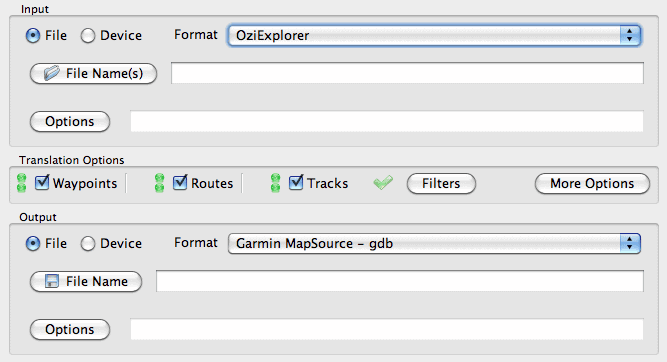
Key Features of GPS Babel
- It converts waypoints, routes, and tracks between popular GPS receivers such as Garmin, Magellan, etc.
- GPS Babel can plot retrieved coordinates into mapping programs like Google Earth and Basecamp.
- It has support for more than 100 GPS devices.
- It can also be used as the backend for other tools.
Final Thoughts
We all know that there are different divisions of geoscience. All of the above tools are the best earth science or geoscience software for Linux in their respective categories. So you may not need to use every software from the above list. You can undoubtedly choose any of the software based on your academic or career needs. If you have any favorite geoscience software you think we missed to mention, you can let us know by commenting below.